Tag: Chattahoochee River
Wikipedia says: The Chattahoochee River forms the southern half of the Alabama and Georgia border, as well as a portion of the Florida – Georgia border. It is a tributary of the Apalachicola River, a relatively short river formed by the confluence of the Chattahoochee and Flint rivers and emptying from Florida into Apalachicola Bay in the Gulf of Mexico. The Chattahoochee River is about 430 miles (690 km) long. The Chattahoochee, Flint, and Apalachicola rivers together make up the Apalachicola–Chattahoochee–Flint River Basin (ACF River Basin). The Chattahoochee makes up the largest part of the ACF’s drainage basin.
The source of the Chattahoochee River is located in Jacks Gap at the southeastern foot of Jacks Knob, in the very southeastern corner of Union County, in the southern Blue Ridge Mountains, a subrange of the Appalachian Mountains. The headwaters of the river flow south from ridges that form the Tennessee Valley Divide. The Appalachian Trail crosses the river’s uppermost headwaters. The Chattahoochee’s source and upper course lie within Chattahoochee National Forest.
From its source in the Blue Ridge Mountains, the Chattahoochee River flows southwesterly to Atlanta and through its suburbs. It eventually turns due-south to form the southern half of the Georgia/Alabama state line. Flowing through a series of reservoirs and artificial lakes, it flows by Columbus, the third-largest city in Georgia, and the Fort Benning Army base. At Columbus, it crosses the Fall Line of the eastern United States.
From Lake Oliver to Fort Benning, the Chattahoochee Riverwalk provides cycling, rollerblading, and walking along 15 miles (24 km) of the river’s banks. Farther south, it merges with the Flint River and other tributaries at Lake Seminole near Bainbridge, to form the Apalachicola River that flows into the Florida Panhandle. The Chattahoochee River ends in the city of Chattahoochee, FL. From there, the same river is then named Apalachicola River, which ends (160 miles away) in the city of Apalachicola, FL (meaning both rivers end in the city named after them). Although the same river, this portion was given a different name by separated settlers in different regions during the colonial times.
American Civil War
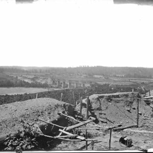
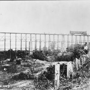
The Chattahoochee River was of considerable strategic importance during the Atlanta Campaign by Union General William Tecumseh Sherman of the American Civil War.
Between the tributaries of Proctor Creek and Nickajack Creek on the Cobb and Fulton county lines in metropolitan Atlanta, are nine remaining fortifications nicknamed “Shoupades” that were part of a defensive line occupied by the Confederate Army in early July 1864. Designed by Confederate Brigadier General Francis A. Shoup, the line became known as Johnston’s River Line after Confederate General Joseph E. Johnston and is listed on the National Register of Historic Places.
A month prior to the Battle of Atlanta, Shoup talked with Johnston on June 18, 1864 about building fortifications. Johnston agreed, and Shoup supervised the building of 36 small elevated earth and wooden triangular fortifications, arranged in a sawtooth pattern to maximize the crossfire of defenders. Sherman tried to avoid the Shoupade defenses by crossing the river to the northeast. The nine remaining Shoupades consist of the earthworks portion of the original earth and wooden structures; they are endangered by land development in the area.
Two of the last battles of the war, West Point and Columbus took place at strategically important crossings of the Chattahoochee.
Showing all 2 results